
How to Plan Tomorrow's Cities?
4 MIN READ
Sam Archie
Data Engineer

Today's urban planning is more complex than ever: climate change, the housing crisis, natural hazards, and chronic disease mean that planning decisions must consider multiple objectives.
Context and Motivation
Today’s urban planning is more complex than ever: climate change, the housing crisis, natural hazards, and chronic disease mean that planning decisions must consider multiple objectives. Aotearoa New Zealand’s planning landscape is also shifting with the recent NPS on Urban Development, the likely introduction of the Strategic Planning Act, and climate risk requirements of the Zero Carbon Act. As a result, future development must enable sustainable and healthy lifestyles, reduce exposure to natural hazards and pollution, and promote equity and community cohesion, often among many other objectives.
Aim
To support this planning, we are developing a sophisticated tool that supports housing agencies, councils, and iwi to identify favourable areas for urban development or intensification that maximises the co-benefits between the community’s objectives.
Method
We use a multi-criteria spatial optimisation approach using a genetic algorithm that evaluates and improves spatial plans based on the community-specific objectives and priorities. Our proof-of-concept tool currently discourages development in areas exposed to hazards and encourages development near key centres.
Partner with us
1. Join our advisory board so we can provide you with updates on the project’s progress and seek regular input from you on what you require
2. Participate as a case study so we can develop the tools in your region, with your data, understanding your needs.
If you’d like to be involved or stay informed, please get in touch with Dr Tom Logan from the Civil System Engineering Department.
027 287 4474
Want to see the results of the current tool in action?
As a case study, we ran the tool using Ōtautahi Christchurch’s projected population increase with the following objectives:
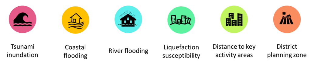
The objectives were weighted to be equally important, eg. being in a tsunami zone is equally as bad as being far away from key activity areas, only to show the effectiveness of the tool.
As seen below, the tool found priority areas for development/densification where there was clear evidence of decreasing exposure to natural and climate hazards, whilst increasing the distance to key activity areas and utilising residentially zoned land.
The height and colour of the extruded statistical areas indicate the relative urban densities; not the height of structures.
How to Plan Tomorrow's Cities? - Urban Intelligence
We're developing a spatial, multi-criteria optimisation approach to support strategic land-use planning that balances climate risk, housing, and community wellbeing.
